AERIAL MAPPING

Drone mapping is simply another form of aerial mapping. Prior to the pervasive use of drones, large areas were mapped using manned aircraft, typically helicopters. Drone mapping is a way to do this job more cost-effectively, safe manner, and productively.
Drones can make accurate maps by combining images, which can be interpolated into three-dimensional imagery with software that utilizes photogrammetric techniques to form orthomosaics and digital surface models. Using control points on the ground, these maps can be produced with horizontal resolutions of 5 to 10 centimetres (cm) and vertical precision within 8 cm. As a result, mapping data can be used to make real-world measurements and to plan activities like slope stability, road construction, and expeditions into remote areas.
In a broader sense, drone mapping is an application of remote sensing technology. Remote sensing would be any method of collecting data that does not require physical contact between the person or measuring device and the object being measured. Some of the more common applications of remote sensing involve satellite imagery and seafloor surveys.


Deliverables We Provide
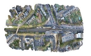
Orthomosaic Maps
Drone images are corrected for image distortion and stitched together to create a highly accurate orthomosaic map during post-processing. Each pixel contains 2D geo-information (X, Y) and can receive accurate measurements, such as horizontal distances and surfaces, directly.

3D Point Cloud
Drone images can be used to create a densified point cloud. Each point contains geospatial (X, Y, Z) and color features. It provides a very accurate methodology for assessing distance (slant and horizontal), area, and volume.
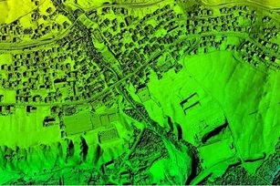
Digital Surface Models (DSM)
Drone images can also be used to create DSM models of the area. Each pixel contains 2D information (X, Y) as well as the altitude (Z value) of the highest point for this position.

Digital Terrain Model (DTM)
After filtering out things like buildings, drone imagery can be used to construct DTMs, with 2.5D information stored in each pixel (X, Y, and Z value of the highest altitude).

Contour Maps
Depending on the project requirements, either the DTM or DSM model, with custom contour intervals, can be used to create a contour lines map, giving you a better understanding of the surface of the area shot by the drone.
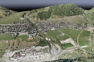
3D Textured Mesh
The 3D textured mesh is a reproduction of the edges, faces, vertices and texture of the area shot by the drone. This model is most useful for visual inspection or for when external stakeholders or public involvement is essential for a project.


CLIENTS FEEDBACK
Talent You Can Trust
our clients


