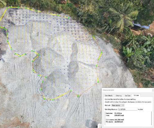
GIS, Remote Sensing & Spatial Analysis
WHAT WE DO
Our aim is to enhance GIS development India by merging geospatial and related technologies with comprehensive business information solutions. We strive to boost our clients’ planning effectiveness and operational efficiency. Achieving this by acting as an integrated extension of our clients’ teams, we employ structured, collaborative, and innovative problem-solving strategies.
![](https://www.senseimage.in/wp-content/uploads/2022/06/GIS-Remote-Sensing-Spatial-Analysis1.jpg)
OUR SERVICES
Sense Image created strategic GIS inception plans to offer structured emphasis from the beginning of the GIS implementation process and ensure that initial efforts are immediately effective while staying flexible and extensible to meet future needs.
Photogrammetry Services
We step forward in photogrammetric project and Terrain data planning, processing and execution. Our services can be customized for project specific requirements, and we also planning for large scale projects as contractors, from inception to completion.
![Aerial Triangulation Orientation](https://www.senseimage.in/wp-content/uploads/2022/06/Aerial-Triangulation-Orientation.jpg)
Aerial Triangulation – Orientation &
Adjustment of a Block
![Digital Terrain Modeling and 3D](https://www.senseimage.in/wp-content/uploads/2022/06/Digital-Terrain-Modeling-and-3D.jpg)
Digital Terrain Modeling and 3D
Visualization
![Contour Generation](https://www.senseimage.in/wp-content/uploads/2022/06/Contour-generation.jpg)
Contour generation
![Orthophoto Generation](https://www.senseimage.in/wp-content/uploads/2022/06/Orthophoto-generation.jpg)
Orthophoto generation
![Planimetric-Mapping Services](https://www.senseimage.in/wp-content/uploads/2022/06/Planimetric-Mapping.jpg)
Planimetric Mapping
![2D & 3D Mapping](https://www.senseimage.in/wp-content/uploads/2022/06/2D-3D-mapping.jpg)
2D & 3D mapping
![Planimetric Mapping](https://www.senseimage.in/wp-content/uploads/2022/06/Planimetric-Mapping1.jpg)
Planimetric Mapping
LiDAR Data Processing & Mapping
Sense Image offers ALTM / Mobile / Terrestrial / UAV
LiDAR data processing services.
Airborne Laser Terrain Mapping (ALTM) – Sense Image offers low-cost, high-quality LiDAR services that meet international standards. We have extensive experience classifying LiDAR point cloud data into various classes such as bare earth, buildings, bridges, hydrography, low and high vegetation, pyrons, high tension wires and cables, and so on. We also adjust flight lines, do advanced asbuilt 3D modelling, and planimetric mapping
![Airborne Laser Terrain Mapping (ALTM)](https://www.senseimage.in/wp-content/uploads/2022/06/Airborne-Laser-Terrain-Mapping-ALTM.jpg)
![Mobile Handheld LiDAR](https://www.senseimage.in/wp-content/uploads/2022/06/Mobile-Handheld-LiDAR.jpg)
Mobile / Handheld LiDAR: Sense Image offers mobile/handheld solutions. LiDAR’s high-resolution point cloud data gives accurate three-dimensional topography information. It’s useful for mapping since it can accurately survey object elevation and geo-reference location.
UAV Arieal LiDAR: Sense image has a team dedicated to processing UAV LiDAR data, from flight line adjustments to classification of point cloud data to its respective feature class and
vectoring them to create 3D City Modeling.
![UAV Aerial LiDAR](https://www.senseimage.in/wp-content/uploads/2022/06/UAV-Arieal-LiDAR.jpg)
Mining and Volume estimation
calculation of the volume and the tonnage of ore deposits there is a variety of available methods to choose from, each suited for a particular deposit.
![Mining](https://www.senseimage.in/wp-content/uploads/2022/06/Mining.jpg)
Mining
![GIS - Volume Estimation](https://www.senseimage.in/wp-content/uploads/2022/06/Volume-estimation.jpg)
Volume estimation
Building Information Modelling (BIM)
BIM – The process of creating and managing building data is known as building
information modelling (BIM). BIM models can provide comprehensive construction
information that 2D drawings alone cannot provide. It will also be useful to assess building compliance with various safety norms and guidelines, such as fire safety, setback, construction ratio, and open spaces, among others, before granting registration or a licence to use the structure/facility.
![Building Information Modelling (BIM)](https://www.senseimage.in/wp-content/uploads/2022/06/Building-Information-Modelling-BIM.jpg)
![Kumar](https://senseimage.in/wp-content/plugins/elementor/assets/images/placeholder.png)
![Ramya](https://senseimage.in/wp-content/plugins/elementor/assets/images/placeholder.png)
CLIENTS FEEDBACK
Talent You Can Trust
our clients
![client5](https://www.senseimage.in/wp-content/uploads/2022/06/client5.jpg)
![client4](https://www.senseimage.in/wp-content/uploads/2022/06/client4.jpg)
![client3](https://www.senseimage.in/wp-content/uploads/2022/06/client3.jpg)
![client2](https://www.senseimage.in/wp-content/uploads/2022/06/client2.jpg)
![client1](https://www.senseimage.in/wp-content/uploads/2022/06/client1.jpg)
![cleint6](https://www.senseimage.in/wp-content/uploads/2022/06/cleint6.jpg)
![Techno Vision - Surveying & Mapping](https://www.senseimage.in/wp-content/uploads/2022/06/VISION.jpg)
![VAISHNAVI](https://www.senseimage.in/wp-content/uploads/2022/06/VAISHNAVI.jpg)
![STERLITEPOWER](https://www.senseimage.in/wp-content/uploads/2022/06/STERLITEPOWER.jpg)
![RSI Softech](https://www.senseimage.in/wp-content/uploads/2022/06/SOFTECH1.jpg)
![Tata Projects Limited](https://www.senseimage.in/wp-content/uploads/2022/06/TATA1.jpg)
![ASIA DRONE](https://www.senseimage.in/wp-content/uploads/2022/06/ASIADRONE.jpg)
![Ceylon Electricity Board](https://www.senseimage.in/wp-content/uploads/2022/06/ceylon1.jpg)
![KCG College of Technology Chennai](https://www.senseimage.in/wp-content/uploads/2022/06/KCG.jpg)
![LI](https://www.senseimage.in/wp-content/uploads/2022/06/LI.jpg)
![NTCPWC](https://www.senseimage.in/wp-content/uploads/2022/06/NTC.jpg)
![SDS Global](https://www.senseimage.in/wp-content/uploads/2022/06/SDS.jpg)